Argentina Volcanoes
-
Cordon del Azufre
-
El Solo
-
El Solo
-
Lanin
-
El Condor
-
El Solo
-
Lanin
-

Lanin
-

Huanquihue Group
-
Lanin
-
Socompa
-

Llullaillaco
-
Pali-Aike Volcanic Field
-
Corrida de Cori Volcanic Field
-

Sierra Nevada
-
El Solo
-
Tupungatito
-
Lanin
-

Llullaillaco
-

Copahue
Argentina has 34 Holocene volcanoes. Note that as a scientific organization we provide these listings for informational purposes only, with no international legal or policy implications. Volcanoes will be included on this list if they are within the boundaries of a country, on a shared boundary or area, in a remote territory, or within a maritime Exclusive Economic Zone. Bolded volcanoes have erupted within the past 20 years. Suggestions and data updates are always welcome ().
| Volcano Name | Location | Last Eruption | Primary Volcano Type |
|---|---|---|---|
| Antofagasta Volcanic Field | Northern Argentina | Unknown - Evidence Uncertain | Volcanic field |
| Aracar | Northern Argentina | Unknown - Evidence Credible | Stratovolcano |
| Caldera del Atuel | Central Chile and Argentina | Unknown - Evidence Credible | Caldera |
| Cerro Bayo Gorbea | Northern Chile-Argentina | Unknown - Evidence Credible | Complex |
| Laguna Blanca | Central Chile and Argentina | Unknown - Evidence Credible | Volcanic field |
| Cerro Blanco | Northern Argentina | 2300 BCE | Caldera |
| El Condor | Northern Argentina | Unknown - Evidence Credible | Stratovolcano |
| Copahue | Central Chile-Argentina | 2021 CE | Stratovolcano |
| Cordon del Azufre | Northern Chile-Argentina | Unknown - Evidence Credible | Complex |
| Corrida de Cori Volcanic Field | Northern Chile-Argentina | Unknown - Evidence Uncertain | Stratovolcano |
| Crater Basalt Volcanic Field | Argentina | Unknown - Evidence Credible | Volcanic field |
| Falso Azufre | Northern Chile-Argentina | Unknown - Evidence Uncertain | Complex |
| Huanquihue Group | Central Chile and Argentina | 1750 CE | Stratovolcano(es) |
| Nevado de Incahuasi | Northern Chile-Argentina | Unknown - Evidence Uncertain | Stratovolcano(es) |
| Infiernillo | Central Chile and Argentina | 6890 BCE | Volcanic field |
| Lanin | Central Chile-Argentina | 560 CE | Stratovolcano |
| Lastarria | Northern Chile-Argentina | Unknown - Evidence Credible | Stratovolcano |
| Llullaillaco | Northern Chile-Argentina | 1877 CE | Stratovolcano |
| Maipo | Central Chile-Argentina | 1912 CE | Caldera |
| Sierra Nevada | Northern Chile-Argentina | Unknown - Evidence Credible | Complex |
| Nevados Ojos del Salado | Northern Chile-Argentina | 750 CE | Stratovolcano |
| Pali-Aike Volcanic Field | Southern Chile-Argentina | 5550 BCE | Volcanic field |
| Payun Matru | Central Chile and Argentina | 5050 BCE | Volcanic field |
| Peinado | Northern Argentina | Unknown - Evidence Credible | Stratovolcano |
| Risco Plateado | Central Chile and Argentina | Unknown - Evidence Uncertain | Stratovolcano |
| San Jose | Central Chile-Argentina | 1960 CE | Stratovolcano(es) |
| Socompa | Northern Chile-Argentina | 5250 BCE | Stratovolcano |
| El Solo | Northern Chile-Argentina | Unknown - Evidence Credible | Stratovolcano |
| Tipas | Northern Argentina | Unknown - Evidence Credible | Complex |
| Tromen Volcanic Plateau | Central Chile and Argentina | 1822 CE | Stratovolcano(es) |
| Tronador | Southern Chile-Argentina | Unknown - Evidence Uncertain | Stratovolcano |
| Tupungatito | Central Chile-Argentina | 1987 CE | Stratovolcano |
| Tuzgle | Northern Argentina | Unknown - Evidence Uncertain | Stratovolcano |
| Unnamed | Northern Argentina | Unknown - Evidence Credible | Pyroclastic cone |
Chronological listing of known Holocene eruptions (confirmed or uncertain) from volcanoes in Argentina. Bolded eruptions indicate continuing activity.
| Volcano Name | Start Date | Stop Date | Certainty | VEI | Evidence |
|---|---|---|---|---|---|
| Copahue | 2021 Jul 2 | 2021 Nov 6 | Confirmed | 1 | Observations: Reported |
| Copahue | 2020 Jun 16 | 2020 Nov 2 | Confirmed | 2 | Observations: Reported |
| Copahue | 2019 Aug 2 | 2019 Nov 12 (?) | Confirmed | 2 | Observations: Reported |
| Copahue | 2017 Jun 4 | 2018 Dec 7 | Confirmed | 1 | Observations: Reported |
| Copahue | 2015 Sep 18 ± 3 days | 2017 Feb 22 | Confirmed | 2 | Observations: Reported |
| Copahue | 2014 Jul 4 | 2014 Dec 2 | Confirmed | 2 | Observations: Reported |
| Copahue | 2012 Dec 22 | 2013 Dec 10 | Confirmed | 2 | Observations: Reported |
| Copahue | 2012 Jul 17 | 2012 Jul 19 | Confirmed | 2 | Observations: Reported |
| Copahue | 2000 Jul 1 | 2000 Oct 18 | Confirmed | 2 | Observations: Reported |
| Copahue | 1995 Sep 16 ± 15 days | Unknown | Confirmed | 2 | Observations: Reported |
| Copahue | 1994 Dec 16 ± 15 days | Unknown | Confirmed | 2 | Observations: Reported |
| Nevados Ojos del Salado | [1993 Nov 14] | [1993 Nov 14] | Uncertain | ||
| Aracar | [1993 Mar 28] | [Unknown] | Uncertain | ||
| Copahue | 1992 Jul 22 | 1993 Jul 2 ± 182 days | Confirmed | 2 | Observations: Reported |
| Tupungatito | 1987 Nov 28 | 1987 Nov 30 | Confirmed | 2 | Observations: Reported |
| Tupungatito | 1986 Jan 20 | 1986 Jan 20 | Confirmed | 1 | Observations: Reported |
| Tupungatito | 1980 Jan 10 | 1980 Jan 11 | Confirmed | 2 | Observations: Reported |
| Tupungatito | 1968 Jul 2 ± 182 days | Unknown | Confirmed | 2 | Observations: Reported |
| Tupungatito | 1964 Aug 3 | 1964 Sep 19 (in or after) | Confirmed | 2 | Observations: Reported |
| Copahue | 1961 Jul 2 ± 182 days | Unknown | Confirmed | 2 | Observations: Reported |
| Tupungatito | 1961 May 5 ± 4 days | 1961 Aug 16 (in or after) ± 15 days | Confirmed | 2 | Observations: Reported |
| Tupungatito | 1960 Jul 15 ± 5 days | Unknown | Confirmed | 2 | Observations: Reported |
| San Jose | 1960 Jul 2 ± 182 days | Unknown | Confirmed | 2 | Observations: Reported |
| Copahue | 1960 Jul 2 ± 182 days | Unknown | Confirmed | Observations: Reported | |
| Tupungatito | 1959 Oct 16 | Unknown | Confirmed | 2 | Observations: Reported |
| San Jose | 1959 Jul 2 ± 182 days | Unknown | Confirmed | 2 | Observations: Reported |
| Tupungatito | 1959 Mar 26 ± 5 days | Unknown | Confirmed | 2 | Observations: Reported |
| Tupungatito | 1958 Jan 16 ± 15 days | Unknown | Confirmed | 2 | Observations: Reported |
| Tupungatito | 1946 | 1947 | Confirmed | 2 | Observations: Reported |
| Copahue | 1944 | Unknown | Confirmed | Observations: Reported | |
| Copahue | 1937 | Unknown | Confirmed | 2 | Observations: Reported |
| Tupungatito | 1925 | Unknown | Confirmed | 2 | Observations: Reported |
| Maipo | 1912 | Unknown | Confirmed | 2 | Observations: Reported |
| Maipo | [1908] | [Unknown] | Uncertain | ||
| Tupungatito | 1907 Feb 15 | Unknown | Confirmed | 2 | Observations: Reported |
| Maipo | 1905 Oct 28 | 1905 Oct 30 | Confirmed | 2 | Observations: Reported |
| Tupungatito | 1901 Apr | Unknown | Confirmed | 2 | Observations: Reported |
| Tupungatito | 1897 Jan | 1897 Apr 12 (in or after) | Confirmed | 2 | Observations: Reported |
| San Jose | 1895 | 1897 | Confirmed | 2 | Observations: Reported |
| San Jose | 1889 | 1890 | Confirmed | 2 | Observations: Reported |
| Tupungatito | 1889 | 1890 | Confirmed | 2 | Observations: Reported |
| Tupungatito | [1881] | [Unknown] | Uncertain | ||
| Maipo | [1881] | [Unknown] | Uncertain | ||
| San Jose | 1881 | Unknown | Confirmed | 2 | Observations: Reported |
| Llullaillaco | 1877 May | Unknown | Confirmed | 2 | Observations: Reported |
| Maipo | [1869 Aug 24] | [Unknown] | Uncertain | ||
| Llullaillaco | 1868 Sep | Unknown | Confirmed | 0 | Observations: Reported |
| Copahue | 1867 (?) | Unknown | Confirmed | 2 | Observations: Reported |
| Tupungatito | 1861 | Unknown | Confirmed | 2 | Observations: Reported |
| Llullaillaco | 1854 Feb 10 | Unknown | Confirmed | 2 | Observations: Reported |
| San Jose | 1838 | Unknown | Confirmed | 1 | Observations: Reported |
| Maipo | [1837] | [Unknown] | Uncertain | ||
| Tupungatito | [1835] | [Unknown] | Uncertain | ||
| Maipo | [1835] | [Unknown] | Uncertain | ||
| Maipo | [1833] | [Unknown] | Uncertain | ||
| Maipo | [1831 Feb 16] | [Unknown] | Uncertain | ||
| Maipo | 1829 Sep 26 | Unknown | Confirmed | 2 | Observations: Reported |
| Tupungatito | 1829 | Unknown | Confirmed | 2 | Observations: Reported |
| Maipo | 1826 Mar 1 | Unknown | Confirmed | 2 | Observations: Reported |
| San Jose | 1822 Nov 19 | 1838 | Confirmed | 2 | Observations: Reported |
| Maipo | [1822] | [Unknown] | Uncertain | ||
| Tromen Volcanic Plateau | 1822 | Unknown | Confirmed | Observations: Reported | |
| Maipo | [1788] | [Unknown] | Uncertain | ||
| Copahue | [1759 (?)] | [Unknown] | Uncertain | ||
| Tromen Volcanic Plateau | 1751 Dec 31 ± 365 days | Unknown | Confirmed | 3 | Observations: Reported |
| Copahue | 1750 (?) | Unknown | Confirmed | 2 | Observations: Reported |
| Huanquihue Group | 1750 ± 100 years | Unknown | Confirmed | Isotopic: 14C (uncalibrated) | |
| Nevados Ojos del Salado | 0750 ± 250 years | Unknown | Confirmed | Correlation: Tephrochronology | |
| Lanin | 0560 ± 150 years | Unknown | Confirmed | Isotopic: 14C (calibrated) | |
| Lanin | 0400 ± 150 years | Unknown | Confirmed | Isotopic: 14C (calibrated) | |
| Lanin | 0090 ± 300 years | Unknown | Confirmed | 0 | Correlation: Tephrochronology |
| Lanin | 0080 BCE ± 200 years | Unknown | Confirmed | Isotopic: 14C (calibrated) | |
| Lanin | 0220 BCE ± 200 years | Unknown | Confirmed | Isotopic: 14C (calibrated) | |
| Copahue | 0250 BCE (?) | Unknown | Confirmed | Isotopic: 14C (uncalibrated) | |
| Lanin | 0590 BCE ± 200 years | Unknown | Confirmed | Isotopic: 14C (calibrated) | |
| Cerro Blanco | 2300 BCE ± 160 years | Unknown | Confirmed | 7 | Isotopic: 14C (calibrated) |
| Payun Matru | 5050 BCE ± 1000 years | Unknown | Confirmed | 0 | Isotopic: K/Ar |
| Socompa | 5250 BCE (?) | Unknown | Confirmed | Isotopic: 14C (uncalibrated) | |
| Pali-Aike Volcanic Field | 5550 BCE ± 2500 years | Unknown | Confirmed | Correlation: Anthropology | |
| Lanin | 6340 BCE ± 200 years | Unknown | Confirmed | Isotopic: 14C (calibrated) | |
| Copahue | 6820 BCE (?) | Unknown | Confirmed | Isotopic: 14C (uncalibrated) | |
| Infiernillo | 6890 BCE ± 40 years | Unknown | Confirmed | Isotopic: 14C (uncalibrated) | |
| Lanin | 9240 BCE ± 500 years | Unknown | Confirmed | Isotopic: 14C (calibrated) |
Argentina has 20 Pleistocene volcanoes. Note that as a scientific organization we provide these listings for informational purposes only, with no international legal or policy implications. Volcanoes will be included on this list if they are within the boundaries of a country, on a shared boundary or area, in a remote territory, or within a maritime Exclusive Economic Zone. Suggestions and data updates are always welcome ().
| Volcano Name | Location | Primary Volcano Type |
|---|---|---|
| Antofalla | Argentina | Stratovolcano(es) |
| Auca Mahuida Volcanic Field | Central Chile and Argentina | Volcanic field |
| Cochiquito Volcanic Group | Central Chile and Argentina | Stratovolcano(es) |
| Cerro Colorado | Argentina | Stratovolcano |
| Domuyo | Central Chile and Argentina | Stratovolcano |
| Cerro Galan | Argentina | Caldera |
| Gemelos-Saladillo | Argentina | Pyroclastic cone(s) |
| Incapillo | Argentina | Caldera |
| Llancanelo Volcanic Field | Central Chile and Argentina | Pyroclastic cone(s) |
| Cerro Nevado | Central Chile and Argentina | Volcanic field |
| Northern Mendoza Volcanic Field | Central Chile and Argentina | Volcanic field |
| Cerro Pantoja | Central Chile and Argentina | Stratovolcano |
| Pino Hachado | Central Chile and Argentina | Caldera |
| Nevado de los Piuquenes | Central Chile and Argentina | Stratovolcano |
| Nevado Queva | Argentina | Unknown |
| Tocomar | Argentina | Unknown |
| Tralihue | Central Chile and Argentina | Stratovolcano |
| Cerro Trautrén | Central Chile and Argentina | Stratovolcano(es) |
| Trolon | Central Chile and Argentina | Lava dome(s) |
| Tupungato | Central Chile and Argentina | Stratovolcano |
There are 56 photos available for volcanoes in Argentina.
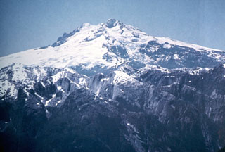 The western side of glacier-covered Monte Tronador volcano overlies rugged granitic peaks of the Northern Patagonian Batholith in the foreground. Activity at the Tronador volcanic group, which straddles the Chile-Argentina border east of scenic Lake Todos los Santos, dates back to the early Pleistocene and ended during the mid-Pleistocene. The only possible Holocene activity in the volcano group took place SSE of Monte Tronador, forming the post-glacial Fonck cinder cone and lava flow.
Photo by Oscar González-Ferrán (University of Chile).
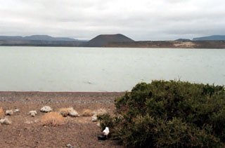 A pristine cinder cones rises to the west above the shores of Laguna Blanca, namesake of the Laguna Blanca National Park in Argentina. The park is noted for its aquatic bird fauna, including black-necked swans and flamingos. Youthful-looking basaltic to trachyandesitic cinder cones and small shield volcanoes of the Laguna Blanca volcanic field are considered to be of Holocene age, although no radiometric ages are available.
Photo courtesy of Johan Varekamp (Wesleyan University).
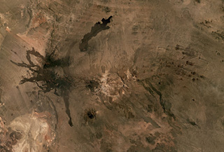 The Cerro Payún Matru volcanic field in Argentina covers 5,200 km2 and contains a roughly 9-10 km diameter caldera in the center of this Planet Labs satellite image monthly mosaic (N is at the top; this image is approximately 81 km across). The caldera is associated with an ignimbrite deposit spanning 2,200 km2, and since its formation 168,000 years ago over 300 vents erupted. There are several larger cones with Cerro Payún reaching the highest elevation SSW of the caldera. The Pampas Negras lavas are to the W, and the Santa Maria lava flow is N of the caldera.
Satellite image courtesy of Planet Labs Inc., 2019 (https://www.planet.com/).
 Conical Maipo volcano rises above the floor of Diamante caldera in this NASA International Space Station view (with north to the top). A series of flank vents on the eastern side of the volcano produced lava flows that give the western shoreline of Laguna Maipo and irregular outline; a lava flow in 1826 blocked drainages on the caldera floor, forming the lake. The 15 x 20 km Diamante caldera was formed during a major explosion eruption about 450,000 years ago.
NASA International Space Station image ISS009-E-7182, 2004 (http://eol.jsc.nasa.gov/).
 Risco Plateado covers an area of 910 km2 and has a steep mountainous relief partly due to glacial erosion, shown in this February 2021 Planet Labs satellite image monthly mosaic (N is at the top; this image is approximately 15 km across). there is a scoria cone on the SE flank, visible in the lower right corner of the image.
Satellite image courtesy of Planet Labs Inc., 2021 (https://www.planet.com/).
 Cerro Escorial (center horizon), viewed from the summit of Lastarria volcano, is a small andesitic-dacitic stratovolcano that straddles the Chile/Argentina border. Very youthful-looking lava flows of uncertain age are seen here extending 3-4 km SW-ward over an ignimbrite deposit on the Chilean side of the border. Cerro Escorial is located 4 km NE of an active sulfur mine in older, extensively hydrothermally altered rocks, some of which are seen in the middle ground.
 Photo by José Naranjo, 1983 (Servico Nacional de Geologica y Mineria).
 The world's highest historically active volcano, 6739-m-high Llullaillaco, sits astride the Chile-Argentina border. The summit, seen here from the NE, is formed by a smaller well-preserved cone that was constructed on an older edifice dating back to the early Pleistocene. A major debris-avalanche deposit produced by collapse of the older volcano extends eastward into Argentina. Growth of the modern cone was completed with the emplacement of a series of young lava flows down the northern and southern flanks.
 Photo by Carlos Felipe Ramírez, courtesy of Oscar González-Ferrán (University of Chile).
 Volcán Copahue is a composite volcano constructed along the Chile-Argentina border within an 8-km-wide Pleistocene caldera. The eastern summit crater, part of a 2-km-long, ENE-WSW line of nine craters, contains the briny El Agrio crater lake and displays intense fumarolic activity. Infrequent explosive eruptions have been recorded since the 18th century from the 2965-m-high volcano.
 Photo by Hugo Moreno (University of Chile).
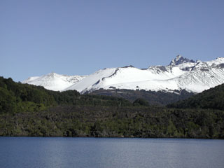
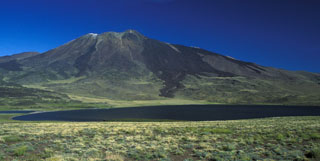 Dark-colored lava flows descend the northern flank of Volcán Tromen, a 3978-m-high Argentinian stratovolcano in this view from La Laguna del Tromen, NW of the volcano. This and another lake at the NW foot the volcano are renowned for their exotic bird life, including flamingos. The youngest lava flows at Tromen originated from flank vents and descended the north and NE sides of the andesitic-to-rhyolitic volcanic complex. Historical eruptions of Tromen were reported in the mid-18th century and in 1822.
 Photo by Olivier Galland, 2007 (University of Oslo).
 The small stratovolcano surrounded by an apron of lava flows in the center of this NASA Landsat image (with north to the top) is Cochiquito volcano. The alkaline basaltic volcano has eight satellitic cones and lies near the junction of the Río Barrancas (cutting diagonally across the image from the upper left) and the Río Grande (right-center). Lava flows from the Sillanegra pyroclastic cone complex can be seen across the Río Grande below and to the right of Cochiquito.
NASA Landsat 7 image (worldwind.arc.nasa.gov)
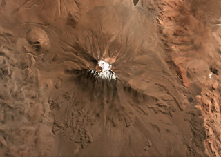
 The Tipas volcanic complex is located in Argentina and is shown in this September 2019 Planet Labs satellite image monthly mosaic (N is at the top; this image is approximately 10 km across). The complex spans 25 km2 and consists of craters, cones, lava domes and flows.
Satellite image courtesy of Planet Labs Inc., 2021 (https://www.planet.com/).
 The Cochiquito Volcanic Group includes this scoria cone and lava field, seen in this October 2019 Planet Labs satellite image monthly mosaic (N is at the top). The N-S length of this lava field is approximately 7 km and the crater is approximately 250 m in diameter.
Satellite image courtesy of Planet Labs Inc., 2019 (https://www.planet.com/).
 The elongated NNW-trending edifice of 5697-m-high Lastarria volcano rises above pyroclastic-flow deposits that form an extensive apron below the northern flanks of the volcano. Five nested craters are found along a semi-arcuate line on the summit ridge. The youngest feature is a lava dome that overlaps the northern crater rim. Persistent fumarolic activity occurs at the summit and NW flank, and small sulfur flows 350 m long have been produced by melting of extensive sulfur deposits in the summit region.
Photo by Paula Cornejo, courtesy of Oscar González-Ferrán (University of Chile).
 Snow and ice drapes the western flank of Nevado Incahuasi along the Chile/Argentina border, as seen from Paso las Lozas at 5100 m. Nevado de Incahuasi is a complex volcanic massif located ENE of Nevados Ojos del Salado volcano. Two stratovolcanoes occupy a compound 3.5 -km-wide caldera. Pleistocene lava domes are located on the west and SW flanks of the 6621-m-high Nevado de Incahuasi, one of the world's highest volcanoes.
 Photo by Oscar González-Ferrán (University of Chile).
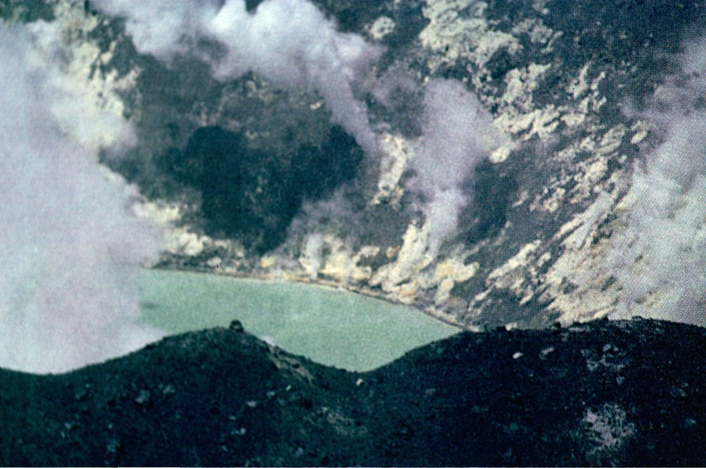
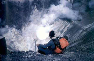
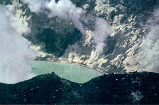 Steam plumes rise from abundant solfataras lining the shores of the acid crater lake where the eruptive activity took place at Tupungatito during the 1960s.
Photo by Alejo Contreras (courtesy of Oscar González-Ferrán, University of Chile).
 The world's highest historically active volcano, Llullaillaco, sits astride the Chile-Argentina border in this NASA International Space Station image (with north to the upper right). A well-preserved summit cone was the source of prominent lava flows that are older than they appear in this image. The hilly terrain at the lower right was produced by a major debris avalanche about 150,000 years ago that swept eastward into Argentina and diverges around the north and south sides of the older Cerro Rosado stratovolcano (extreme lower right).
NASA International Space Station image ISS006-E-13814, 2003 (http://eol.jsc.nasa.gov/).
 The dacitic volcanic complex of El Muerto abuts Nevados Ojos del Salado volcano on the east and NE. The summit of this massive complex contains dacitic lava domes and is cut by a 2.5-km-long depression containing a dozen eruptive centers; an additional two dozen centers lie outside the depression. Lava flows from these centers cover an area of 120 km2. The summit lava domes are of Pleistocene age, but the complex is cut by ENE-trending fractures that formed during Holocene eruptions of Ojos del Salado.
Photo by Oscar González-Ferrán (University of Chile).
 Tupungatito volcano, the northernmost historically active volcano of the central Chilean Andes, is the broad, glacier-clad massif at the right center. The glacial icecap fills the southern side of the Pleistocene Nevado Sin Nombre caldera, which is breached to the NW, in the direction of this photo. A dozen Holocene craters are found at Tupungatito, which has produced frequent mild explosive eruptions during the 19th and 20th centuries. Tupungatito is located immediately SW of Pleistocene Tupungato volcano, the large conical peak at the left.
 Photo by Sergio Kunstmann-Z, courtesy of Oscar González-Ferrán (University of Chile).
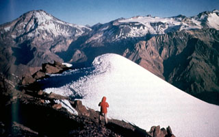
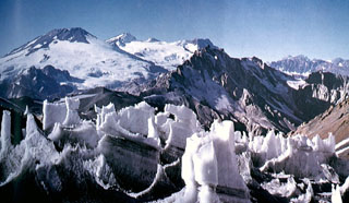 Volcán San José on the far left horizon rises to the north above ice pinnacles at the Nieves Negras pass on the Chile/Argentina border. The summit of San José is formed by a cluster of six Holocene craters, pyroclastic cones, and blocky lava flows that lie within a series of elongated, 0.5 x 2 km wide nested craters. Mild phreatomagmatic eruptions were recorded at San José in the 19th and 20th centuries.
 Photo courtesy of Oscar González-Ferrán (University of Chile).
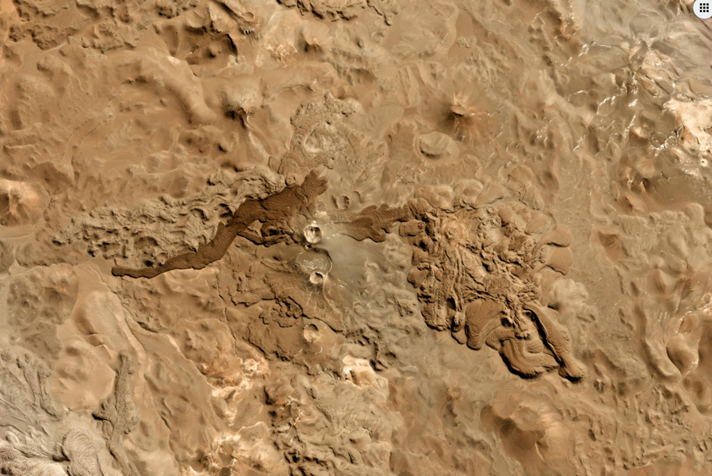
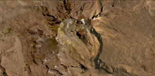
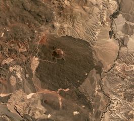
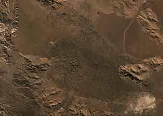
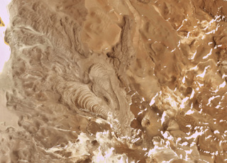
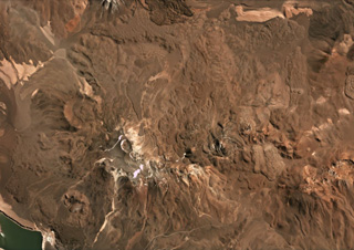
 Cordón del Azufre is in the center of this 22 May 2019 Planet Scope satellite image (N is at the top), located along the Chile-Argentina border. The darker lava flow originated from Volcán la Moyra, the youngest feature of the volcanic field, reaching 6 km to the W. The complex includes a N-S chain of four craters and numerous lava flows.
Satellite image courtesy of Planet Labs Inc., 2019 (https://www.planet.com/).
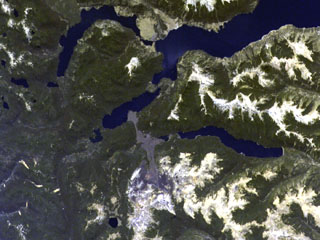
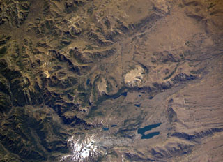
 The small volcanic center with the crater outlined by snow just to the left of the bottom center of this NASA International Space Station image (with north to the upper right) is Cerro Pantoja. This eroded basaltic-andesite volcano of Pleistocene age along the Chile-Argentina border has a Holocene cinder cone on the Argentinian side. The deep blue lake at right-center is Lago Constancia, and the large stratovolcano with a snow-filled summit crater at the top of the image is Puyehue.
 NASA International Space Station image ISS006-E-40413, 2003 (http://eol.jsc.nasa.gov/).
 Maipo volcano, seen here from the west, partially fills the Pleistocene Diamante caldera. The floor of the large 15 x 20 km caldera, which formed about 0.45 million years ago during an eruption that produced a 450 cu km ignimbrite, is visible below Maipo. The 5264-m-high basaltic-andesite stratovolcano has a relatively simple structure, but has a flank rhyodacitic lava-dome complex and pyroclastic cones on its eastern flank. Lava flows from these cones extend into Laguna Diamante on the eastern side of the caldera.
Photo by Wolfgang Foerster, courtesy of Oscar González-Ferrán (University of Chile).
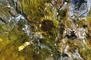
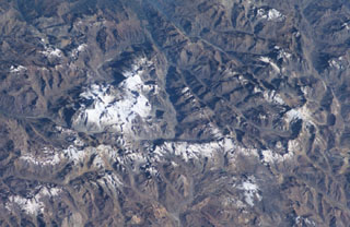
 This April 2019 Planet Labs satellite image monthly mosaic (N is at the top; this image is approximately 23 km across) highlights the lava flow morphologies of the Sierra Nevada complex in Chile. The complex covers around 225 km2 and has at least 12 vents with associated lava flows. The 1-km-wide Cumbre del Laudo crater is on the eastern end with an oxidized scoria deposit around the vent.
Satellite image courtesy of Planet Labs Inc., 2019 (https://www.planet.com/).
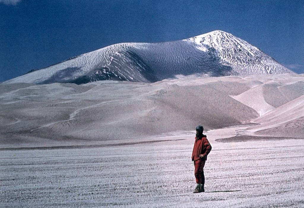
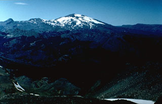
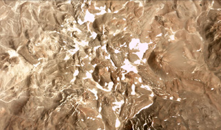
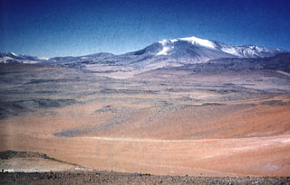
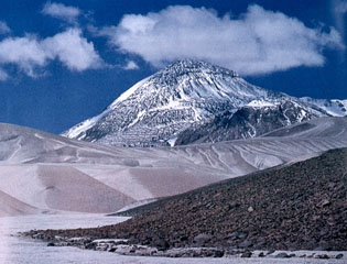
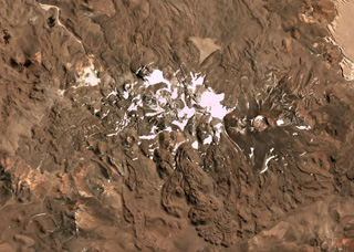
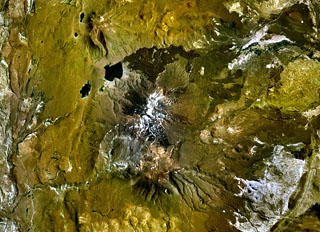
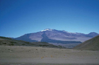
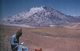
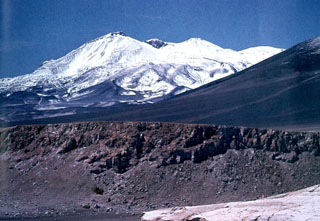
 Light-colored rhyodacitic pyroclastic-flow deposits blanket El Solo volcano in the Ojos del Salado area. Snow partially mantles the summit of El Solo, a stratovolcano composed of nine eruptive centers located west of Nevados del Ojos de Salado and SE of Tres Cruces volcano. The 6190-m-high El Solo volcano was the source of major pyroclastic-flow deposits erupted during the Holocene that thickly fill adjacent valleys.
 Photo courtesy of Oscar González-Ferrán (University of Chile).
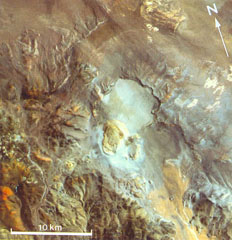 The circular light-colored area in the center of this Thematic Mapper image is the 6-km-wide Robledo caldera. The Cerro Blanco del Robledo rhyolitic lava dome on the southern rim of the caldera was extruded into a pumice cone (pale tones). The margins of pyroclastic flows erupted prior to extrusion of the lava dome are faintly visible on the caldera floor and on the NW flanks of the caldera. Satellite geodetic surveys in the central Andes showed subsidence of Robledo caldera in the 1990s.
 Thematic Mapper image (de Silva and Francis, 1991; courtesy of Matthew Pritchard, California Institute of Technology).
 Strong fumarolic activity occurs in the crater where the phreatomagmatic eruptions of the past two decades took place. A dozen Holocene post-caldera craters and cones are located at the NW end of the 4-km-wide, Pleistocene Nevado Sin Nombre caldera.
 Photo by Alejo Contreras (courtesy of Oscar González-Ferrán, University of Chile).
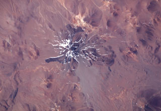
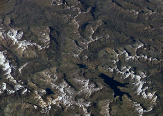
 The snow-mantled surface of Llullaillaco volcano is seen in this NASA International Space Station image (with north to the upper left). The two youthful looking lava flows with prominent flow levees descending the northern and western flanks of the volcano appeared to be of Holocene, but Ar/Ar dating showed them to be of late-Pleistocene age. Llullaillaco is the world's highest historically active volcano.
NASA International Space Station image ISS006-E-13814, 2003 (http://eol.jsc.nasa.gov/).
 The blocky, partially forested Escorial lava flow in the foreground originated from Achín-Niellu (also known as Achen Niyeu or Cerro Escorial) pyroclastic cone (center). The Escorial lava flow traveled north into glacial Lago Epulafquen, forming a prominent lava delta. Oral accounts of local residents stated that the flow was witnessed by their grandparents, who described the eruption of smoke, ash, and lava that changed the shoreline of the lake.
Photo by Moshe Inbar, 1995 (University of Haifa).
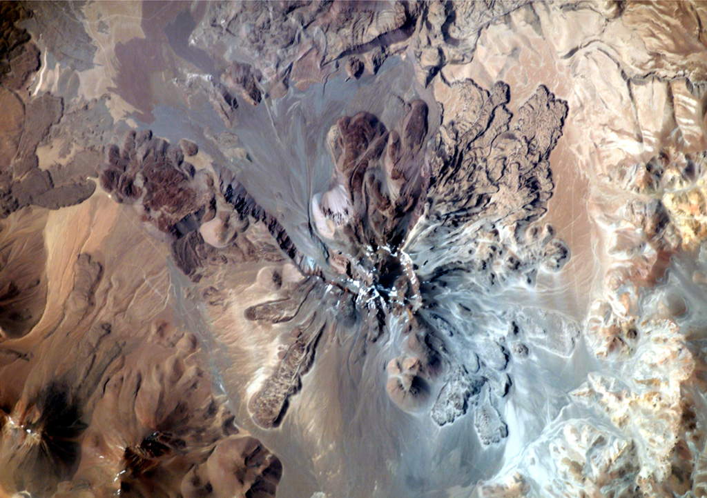
 Tuzgle volcano is located in the Puna Plateau, NW Argentina, shown in this July 2019 Planet Labs satellite image monthly mosaic (N is at the top; this image is approximately 20 km across). The flanks are composed of lava flows radially emplaced from the summit, with the youngest flow on the SW and upper N and S flanks, and additional younger flows on the northern and E flanks.
Satellite image courtesy of Planet Labs Inc., 2019 (https://www.planet.com/).
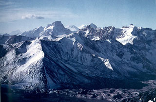
 Quetrupillan stratovolcano (left) lies at the center of a group of three volcanoes trending transverse to the Andean chain. It is seen here from the summit of Villarrica volcano (at the western end of the chain), with conical Lanín volcano at the eastern end in the background. The 2360-m-high Quetrupillan volcano was constructed within a large 7 x 10 km wide caldera; a smaller caldera truncates the summit. Some of the most recent activity produced pyroclastic cones along the right-hand flank, near the SW margin of the older caldera.
 Photo by Judy Harden, 2004 (University of South Florida).
 Tromen (center) is a 3978-m-high youthful Argentinian stratovolcano that lies at the northern end of an elongated volcanic massif. The summit of Tromen is cut by two overlapping 3.5-km-wide calderas, visible south of the snow-dappled summit cone in this NASA Landsat view (with north to the top). The youngest lava flows at Tromen originated from north-flanks vents and produced the dark-colored lava flows that blanket the north and NE sides of the andesitic-to-dacitic volcano.
 NASA Landsat 7 image (worldwind.arc.nasa.gov)
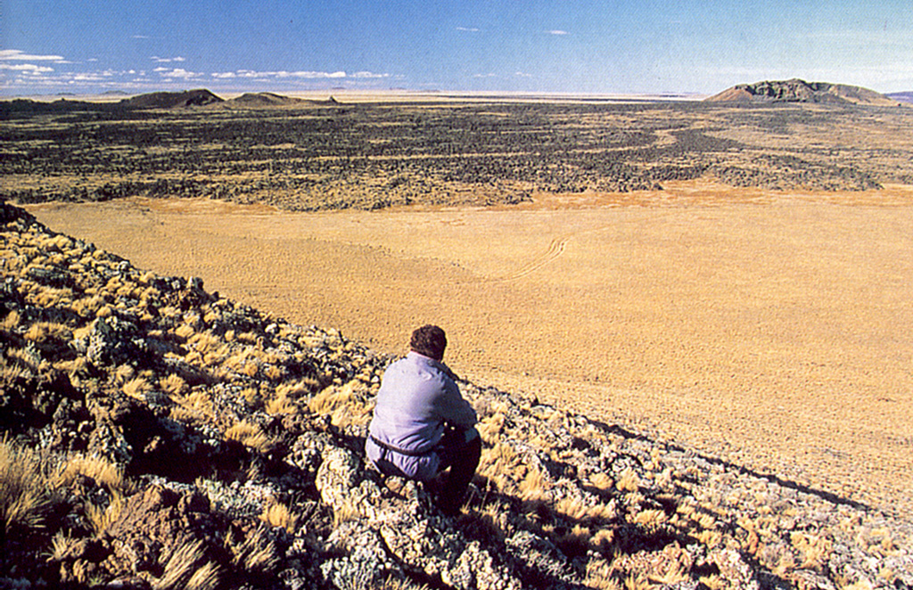
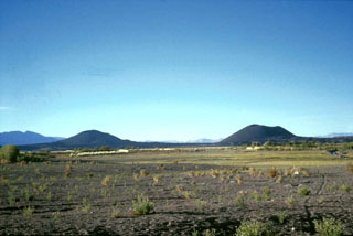
 A lava flow of the Pleistocene-to-Holocene Palei-Aike volcanic field is seen here from Cerro del Diablo. The large volcanic field straddles the Chile/Argentina border north of the Straits of Magellan. The southernmost of the Patagonian basaltic plateau lavas, Palei-Aike contains lake-filled maars and basaltic scoria and spatter cones with associated fresh-looking lava flows.
 Photo by Andres Figueroa Zurita (courtesy of Oscar González-Ferrán, University of Chile).
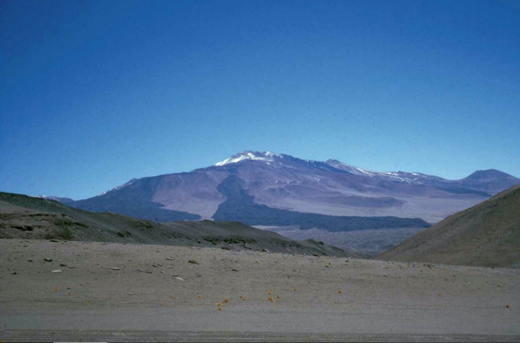
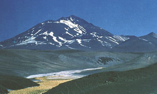
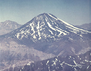
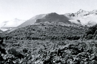
 Fresh-looking lava flows drape the southern flanks of the compound volcano of Cerro el Cóndor, one of the few large stratovolcanoes located entirely in Argentina. The summit complex lies within a 2.5-km-wide caldera and contains several ash cones and craters that have been the source of a number of pristine lava flows that have descended to beyond the flanks of the volcano. The morphologically youthful lava flows and pristine summit crater imply a Holocene age.
 Photo by Ben Edwards, 1998 (Dickinson College, Pennsylvania).
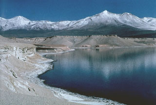 Dacitic pumice from Holocene eruptions of Nevados Ojos del Salado volcano lines the shores of Laguna Verde, NNE of the volcano. The lake lies near the Chile-Argentina border, between Mulas Muertas and Falso Azufre volcanoes.
Photo by Oscar González-Ferrán (University of Chile).
 The snow-covered area at the upper left in this NASA International Space Station image (with north to the lower right) is the Volcán Domuyo volcanic complex. This 4709-m-high Argentinian volcano contains at least 14 dacitic lava domes and other eruptive centers within a 16-km-wide caldera, and at least another 5 lie outside the caldera. Elongated Laguna Valvarco at the lower right lies along the western margin of the Pleistocene Valvarco caldera.
NASA International Space Station image ISS008-E-7432, 2003 (http://eol.jsc.nasa.gov/).
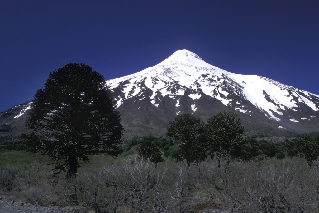
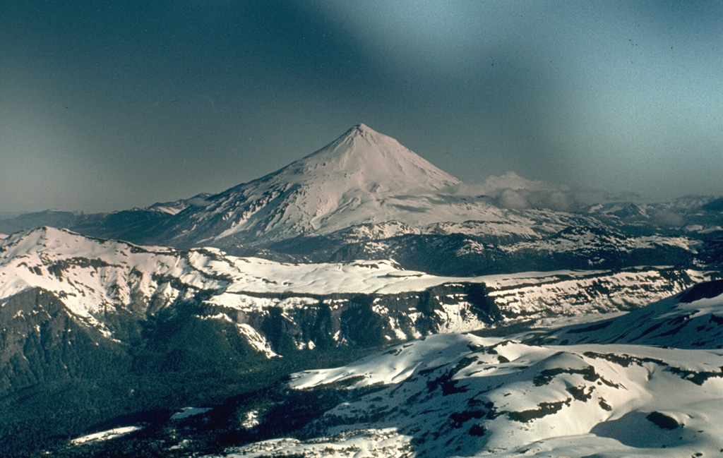
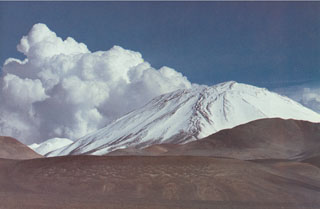
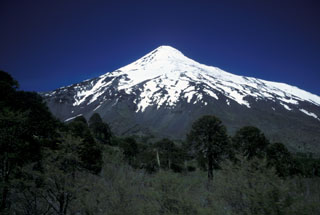
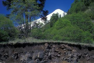
 Lanín volcano rises to the south above a grove of distinctive Araucaria trees near the Chile/Argentina border. The beautifully symmetrical, 3737-m-high Lanín towers 2500 m above its base. The prominent shoulder area on the upper western (right horizon) and northern flanks hint at a buried caldera. The volcano was formed by dominantly effusive basaltic-to-trachydacitic eruptions at the eastern end of a NW-SE-trending volcanic group beginning with Villarrica on the west that is transverse to the Andean chain.
 Photo by Lee Siebert, 2004 (Smithsonian Institution).
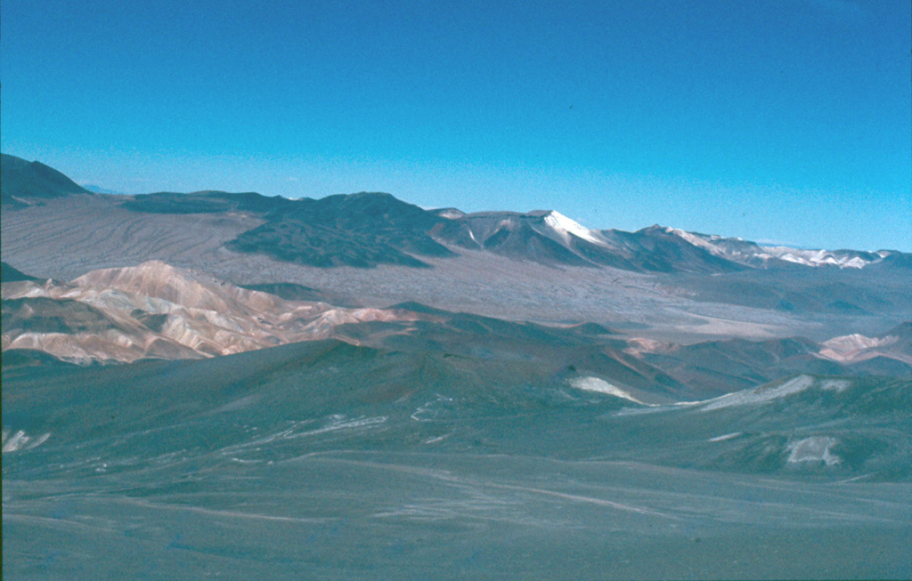
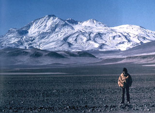
 The Antofagasta de la Sierra volcanic field, located between the elongated NE-SW-trending Salar de Antofalla and the massive Cerro Galán caldera to the east, contains the youngest volcanic vents of the Argentinian Puna region. The area includes several "extremely youthful" scoria cones, such as the ones seen here from the SW. Some cones have been estimated to be only a few thousand years old.
 Photo by Ben Edwards, 1998 (Dickinson College, Pennsylvania).
 Volcán Socompa is a massive, 6051-m-high dacitic stratovolcano noted for an eruption about 7200 years ago, similar to that at Mount St. Helens in 1980. The Socompa eruption produced a massive 600 km2 debris-avalanche deposit, much larger than at St. Helens, that extends about 40 km from the summit. This view from the north shows dark-colored post-collapse lava domes on the right side that have filled much of the head of the massive collapse scarp, which extends to the base of the volcano at the lower right.
 Photo by Carlos Felipe Ramírez (courtesy of Oscar González-Ferrán, University of Chile).
 The NW rim of Diamante caldera in the center of the image rises above the caldera floor in the foreground. The caldera was formed during voluminous rhyolitic explosive eruptions about 450,000 years ago that produced ashflows that extended radially more than 100 km from the caldera, covering much of the Central Valley of Chile and extending into Argentina. The conical snow-capped peak on the center horizon beyond rugged intervening peaks of the Andes is San José volcano.
Photo by Oscar González-Ferrán (University of Chile).
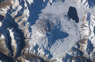
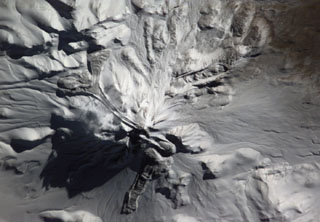
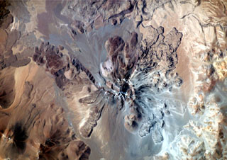 This dramatic NASA International Space Station image (with north to the upper right) is of Socompa volcano. A large horseshoe-shaped caldera breached to the NW was the source of a major debris avalanche about 7,000 years ago that extended beyond the upper left margin of the image. Young dacitic lava domes and flows partially fill the collapse amphitheater, and prominent lava flows with flow levees are visible on the outer flanks.
NASA International Space Station image ISS003-E-5375, 2001 (http://eol.jsc.nasa.gov/).
 The world's highest Holocene volcano, Nevados Ojos del Salado, rises to 6887 m along the border between Chile and Argentina. The summit complex, which is elongated in a NE-SW direction, is seen here from the NW. The massive volcanic complex contains numerous craters, cones, and andesitic and dacitic lava domes. No historical eruptions have been recorded, but the volcano is fumarolically active.
 Photo by Oscar González-Ferrán (University of Chile).
 The Crater Basalt Volcanic Field in Argentina covers around 700 km2, with a portion of the field shown in this July 2019 Planet Labs satellite image monthly mosaic (N is at the top; this image is approximately 33 km across). There are at least nine scoria cones across the field as well as the mostly pahoehoe lava flows reaching out to 5 km.
Satellite image courtesy of Planet Labs Inc., 2019 (https://www.planet.com/).
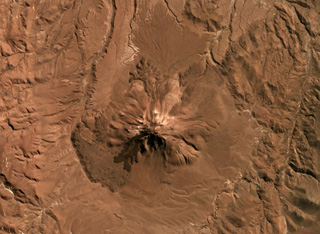
 Aracar volcano in Argentina has a 1.5-km-wide summit crater in the center of this May 2019 Planet Labs satellite image monthly mosaic (N is at the top; this image is approximately 22 km across). Lobate lava flows with pressure ridges are exposed along the lower southern flanks, and lava flows have been emplaced around topographic highs on the W, E, and S.
Satellite image courtesy of Planet Labs Inc., 2019 (https://www.planet.com/).
 The linear grayish lava flow extending into two lakes at the center originated from the Achín-Niellu cinder cone in the snow-covered area at the bottom-center of this NASA Space Station image with north to the upper left. The distal end of 7.5-km-long flow forms a large delta into Lago Epulafquen. A cinder cone separates this lake (known in the Machupe language as "Two Lakes") from the large lake at the upper right, Lago Huechulafquen. The lake at the right-center is Lago Curruhué.
 NASA International Space Station image ISS004-E-7197, 2002 (http://eol.jsc.nasa.gov/).
 The Cerro Bayo volcanic complex is along the Chile-Argentina border east of the Salar de Gorbea and is shown in this 21 October 2019 Planet Scope satellite image (N is at the top; the image is approximately 11.5 km across). A 430-m-diameter crater is visible at the summit of a scoria cone, and to the W are lobate lava flows with levees and pressure ridges.
Satellite image courtesy of Planet Labs Inc., 2019 (https://www.planet.com/).
 The small snow-free crater at the upper right, above and to the right of the light-colored area just right of the center of this NASA International Space Station image (with north to the upper left) is Trolon volcano. It lies in Argentina NE of the Caldera del Agrio (lower right), whose floor contains several lakes, including the U-shaped one at lower right near the SE caldera wall. Trolon is a lava-dome complex with two summit craters and a pyroclastic cone. Snow-covered Copahue volcano (bottom left-center) overlies the western rim of Caldera del Agrio.
NASA International Space Station image ISS006-E-39998, 2003 (http://eol.jsc.nasa.gov/).
 Snow-capped Lanín volcano rises to the SSW above the Chile/Argentina border. A grove of distinctive Araucaria trees ("monkey puzzle trees") occupy the foreground. These distinctive trees are one of Chile's most renowned conifers and are confined to restricted areas in the Andes. Fossils reveal that this genus was once extremely widespread, leaving behind petrified woods in Arizona and amber deposits around the globe. The Auracaria occurs today only in Chile, one small region in Brazil, a few places in Australia, and New Caledonia.
Photo by Lee Siebert, 2004 (Smithsonian Institution).
 The blocky, partially forested Escorial lava flow in the foreground is seen from the north on a boat on Lago Epulafguen. The flow originated from the Achín-Niellu pyroclastic cone (center), which is part of the Huanquihué group of young basaltic volcanoes in Argentina near the Chilean border south of Lanín volcano. The Escorial lava flow was erupted about 200 years ago, and local residents recount oral histories of the eruption, which was observed by their grandparents.
 Photo by Héctor Osvaldo González, 2007.
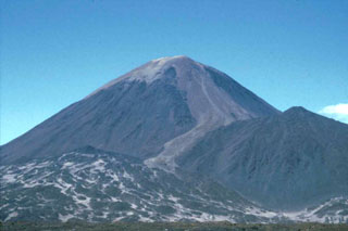 Lighter-colored pyroclastic material blankets the summit of Cerro Peinado, and a possible pyroclastic-flow deposit descends the right-hand flank. This symmetrical Argentinian stratovolcano, one of the youngest in the region, is the source of well-preserved lava flows of Holocene age from summit and flank vents. An apron of pristine lava flows surrounds the volcano and was erupted from the main cone and from vents on the flank, including a prominent ESE-flank vent.
 Photo by Ben Edwards, 1998 (Dickinson College, Pennsylvania).
 The lava flow in the foreground roadcut is part of the Quillelhue Basalts, which were erupted from an area at about 2600 m altitude on the NNW flank of Lanín, the snow-capped volcano in the background. The lavas form a basaltic field that reaches as far as Quillelhue Lake, more than 5 km from their source. The flows are bracketed by 2170 BP date for the Mamuil Malal dacitic block-and-ash flow and a 1650 BP date for an overlying pyroclastic-flow deposit.
 Photo by Lee Siebert, 2004 (Smithsonian Institution).
 The Falso Azufre volcanic complex, covering 387 km2 at the Chile-Argentina border, was constructed largely by lava flows up to 7 km long and 4 km wide, shown in this April 2019 Planet Labs satellite image monthly mosaic (N is at the top; this image is approximately 22 km across). The crater of the Kunstmann edifice is in the upper left corner, and the eastern domes, coulees, and lava flows are to the far right. The summit region craters are aligned along a NW-SE trend to the W (the Falso Azufre edifice), and along a ENE-WSW trend on the eastern side (the Dos Conos edifice).
Satellite image courtesy of Planet Labs Inc., 2019 (https://www.planet.com/).
 The NW side of Nevados Ojos del Salado volcano rises above Pliocene ignimbrites and pyroclastic deposits of the Barranca Blanca. These deposits are overlain by dacitic pyroclastic-flow deposits from Ojos del Salado. A break in slope about half way up the volcano is the rim of a somma, inside which the modern edifice was constructed. Dacitic lava flows from the summit cone periodically overtopped the somma rim.
Photo by Oscar González-Ferrán (University of Chile).
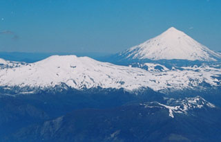
 Volcán Lanín is a large conical late-Pleistocene to Holocene stratovolcano along the Chile-Argentina border. The beautifully symmetrical, 3737-m-high Lanín, seen here from the Chilean side, rises 2500 m above its base. A small lava dome at the summit fed blocky lava flows to the north. A postglacial tuff ring (Volcán Arenal) is located below the SW flank of Lanín in Argentina. A younger lava flow from Lanín covers deposits of Volcán Arenal and extends south into Lago Paimún. No reliable reports of historical eruptions from Lanín are known.
Photo by John Davidson, University of Michigan (courtesy of Hugo Moreno (University of Chile).
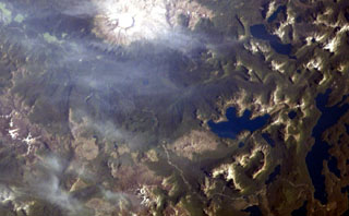
 A complex of snow-covered cones (left-center) partially fills the 30 x 45 km wide Caldera del Atuel, which lies just east of the Argentina-Chile border. The headwaters of the Río del Atuel drain to the SE through a wide breach in the caldera rim (top center) in this NASA International Space Station image (with north to the bottom left). The snow-covered Volcán Overo and Sosneado complexes in the eastern part of the caldera contain numerous very youthful basaltic-to-andesitic pyroclastic cones and lava flows.
 NASA International Space Station image ISS010-E-19060, 2005 (http://eol.jsc.nasa.gov/).
 The broad glacier-covered summit of Volcán Copahue along the Chile/Argentina border is seen from the SE with conical Callaqui volcano in the distance. The lake-filled active crater of Copahue (lower center) has been the site of historical eruptions. The composite cone was constructed along the Chile/Argentina border within an 8-km-wide caldera formed 0.6 million years ago. The eastern summit crater is part of a 2-km-long, ENE-WSW line of nine craters that cuts across the western rim of the caldera.
Photo by Oscar González-Ferrán, 1992 (University of Chile).
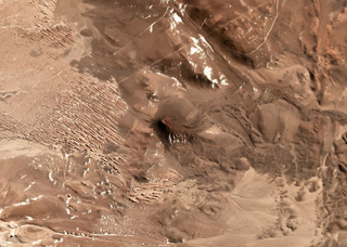 This unnamed scoria cone near the Chile/Argentina border has produced lava flows to the east, visible in this July 2019 Planet Labs satellite image Monthly Mosaic (N is at the top; this image is approximately 8.5 km across). The visible flows have clear lobate or broader flow boundaries, levees, and pressure ridges, while other lavas have been buried by sand deposits.
Satellite image courtesy of Planet Labs Inc., 2019 (https://www.planet.com/).
This is a compilation of Argentina volcano information sources, such as official monitoring or other government agencies.
| Volcano Observatories | |
|---|---|
| Observatorio Argentino de Vigilancia Volcánica (OAVV) | |
| Volcanic Ash Advisory Center | |
|---|---|
| Buenos Aires Volcanic Ash Advisory Center (VAAC) | |
| - Buenos Aires VAAC Archive | |